This map of Europe could make you totally rethink the refugee crisis

A change in perception. Image: REUTERS


Get involved with our crowdsourced digital platform to deliver impact at scale
Stay up to date:
Migration
Since the EU declared a “refugee crisis” in 2015 that was followed by an unprecedented number of deaths in the Mediterranean, maps explaining the routes of migrants to and within Europe have been used widely in newspapers and social media.
Some of these maps came out of refugee projects, while others are produced by global organisations, NGOs and agencies such as Frontex, the European Border and Coastguard Agency, and the International Organisation for Migration’s project, Missing Migrants. The Balkan route, for example, shows the trail along which hundred of thousands of Syrian refugees trekked after their towns and cities were reduced to rubble in the civil war.
However, migration maps tend to produce an image of Europe being “invaded” and overwhelmed by desperate women, men and children in search of asylum. At the same time, migrants’ journeys are represented as fundamentally linear, going from a point A to a point B. But what about the places where migrants have remained stranded for a long time, due to the closure of national borders and the suspension of the Schengen Agreement, which establishes people’s free internal movement in Europe? What memories and impressions remain in the memory of the European citizens of migrants’ passage and presence in their cities? And how is this most recent history of migration in Europe being recorded?
Time and memory
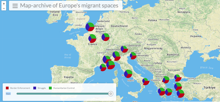
Our collective project, a map archive of Europe’s migrant spaces, engages with with these questions by representing border zones in Europe – places that have functioned as frontiers for fleeing migrants. Some of these border zones, such as Calais, have a long history, while other places have become effective borders for migrants in transit more recently, such as Como in Italy and Menton in France. The result of a collaborative work by researchers in the UK, Greece, Germany, Italy and the US, the project records memories of places in Europe where migrants remained in limbo for a long time, were confronted with violence, or found humanitarian aid, as well as marking sites of organised migrant protest.
All the cities and places represented in this map archive have over time become frontiers and hostile environments for migrants in transit. Take for instance the Italian city of Ventimiglia on the French-Italian border. This became a frontier for migrants heading to France in 2011, when the French government suspended Schengen to deter the passage of migrants who had landed in Lampedusa in Italy in the aftermath of the Tunisian revolutionin 2011.
Four years later in 2015, after border controls were loosened, Ventimiglia again became a difficult border to cross, when France suspended Schengen for the second time. But far from being just a place where migrants were stranded and forced to go back, our map archive shows that Ventimiglia also became an important place of collective migrant protest.
Images of migrants on the cliffs holding banners saying “We are not going back” circulated widely in 2015 and became a powerful slogan for other migrant groups across Europe. The most innovative aspect of our map-archive consists in bringing the context of time, showing the transformations of spaces over time into a map about migration that explains the history of border zones over the last decade and how they proliferated across Europe. Every place represented – Paris, Calais, Rome, Lesbos, Kos, and Athens, for example – has been transformed over the years by migrants’ presence.
Which Europe?
This archive project visualises these European sites in a way that differs from the conventional geopolitical map: instead of highlighting national frontiers and cities, it foregrounds places that have been actual borders for migrants in transit and which became sites of protest and struggle. In this way the map archive produces another image of Europe, as a space that has been shaped by the presence migrants – the border violence, confinement and their struggle to advance.
The geopolitical map of Europe is transformed into Europe’s migrant spaces – that is, Europe as it is experienced by migrants and shaped by their presence. So another picture of Europe emerges: a space where migrants’ struggle to stay has contributed to the political history of the continent. In this Europe migrants are subjected to legal restrictions and human rights violations, but at the same time they open up spaces for living, creating community and as a backdrop for their collective struggles.
It is also where they find solidarity with European citizens who have sympathy with their plight. These border zones highlighted by our map have been characterised by alliances between citizens and migrants in transit, where voluntary groups have set up to provide food, shelter and services such as medical and legal support.
So how does this map engage with debate on the “migrant crisis” and the “refugee crisis” in Europe? By imposing a time structure and retracing the history of these ephemeral border zone spaces of struggle, it upends the image of migrants’ presence as something exceptional, as a crisis. The map gives an account of how European cities and border zones have been transformed over time by migrants’ presence.
By providing the history of border zones and recording memories of citizens’ solidarity with migrants in these places, this map dissipates the hardline view of migrants as invaders, intruders and parasites – in other words, as a threat. This way, migrants appear as part of Europe’s unfolding history. Their struggle to stay is now becoming part of Europe’s history.
But the increasing criminalisation of migrant solidarity in Europe is telling of how such collaboration disturbs state policies on containing migrants. This map-archive helps to erode the image of migrants as faceless masses and unruly mobs, bringing to the fore the spaces they create to live and commune in, embraced by ordinary European citizens who defy the politics of control and the violent borders enacted by their states.
Don't miss any update on this topic
Create a free account and access your personalized content collection with our latest publications and analyses.
License and Republishing
World Economic Forum articles may be republished in accordance with the Creative Commons Attribution-NonCommercial-NoDerivatives 4.0 International Public License, and in accordance with our Terms of Use.
The views expressed in this article are those of the author alone and not the World Economic Forum.
Related topics:
The Agenda Weekly
A weekly update of the most important issues driving the global agenda
You can unsubscribe at any time using the link in our emails. For more details, review our privacy policy.
More on Civil SocietySee all

John Letzing and Minji Sung
April 9, 2024

Marie McAuliffe
April 8, 2024

Mel Young
March 29, 2024

Liam Coleman
March 7, 2024

Laura M. Cha
March 6, 2024

Peter Giger
January 11, 2024