These maps show the world’s rivers in stunning detail

The colors of Fall can be seen reflected in a waterfall along the Blackberry River in Canaan, Connecticut Image: REUTERS/Jessica Rinaldi


Get involved with our crowdsourced digital platform to deliver impact at scale
Stay up to date:
Future of the Environment
- Simple idea, stunning result: the world's watersheds in glorious colors.
- The maps are the work of Hungarian cartographer Robert Szucs.
- His job: to travel and map the world, one good cause at a time.
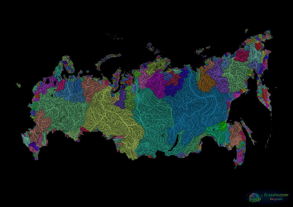
These maps are both data-rich and absolutely gorgeous. You're looking at watershed maps, showing the flow of tributary streams into main rivers, and of those water courses into the sea (or final destinations inland). The streams are shown in the Strahler Stream Order Classification, which uses width to indicate the hierarchy of streams. Watersheds (a.k.a. drainage basins or catchment areas) are grouped together by color.
The maps are the work of Hungarian cartographer Robert Szucs, 33, who combines expertise in GIS with a passion for beautiful maps. "GIS is short for Geographic Information Systems. It's a collective word for anything using spatial or geographic data — from monitoring changes in forest cover with satellite data to creating crime density maps for the police," Szucs explains. "In this case, I've used GIS to create artistic maps, which is a beautiful hybrid of the artsy and geeky sides of my personality."
The world

Africa

Europe

Germany

Great Britain and Ireland

United States

Washington State

Australia

Russia
Szucs has managed to parlay his love for beautiful maps into a job designing them:
"I made a huge elevation map of Eurasia which was used in a documentary about horses and their migrations. There's also a 12-foot wide mural in the making at Louisiana State University, based on one of my maps. And I made some maps for the BBC after they reached out, saying my work inspired a show on rivers. I'm not saying I was jumping on my bed from excitement after any of those requests, but maybe I was."
Szucs is not just a theoretical map enthusiast, but also a practical one. He tries to move to a different country every few months, "donating" his mapmaking skills to worthy causes. He's worked with archeologists on St. Eustatius, an island in the Caribbean, with marine biologists in Alaska, and for an orangutan conservation programme on Borneo, among other destinations.
"My moves are always temporary, linked with volunteering for an NGO. It's a way of developing my skills, but also of seeing the world and experiencing new cultures," Szucs said. Meanwhile, new map ideas bubble up. "My current favourite map as yet only exists in my head as an idea. I might have to learn a few new software applications to make it. Let's hope I can find a way to make it happen. After that, I hope to be back in Alaska for a few months, working with whales again."
Don't miss any update on this topic
Create a free account and access your personalized content collection with our latest publications and analyses.
License and Republishing
World Economic Forum articles may be republished in accordance with the Creative Commons Attribution-NonCommercial-NoDerivatives 4.0 International Public License, and in accordance with our Terms of Use.
The views expressed in this article are those of the author alone and not the World Economic Forum.
The Agenda Weekly
A weekly update of the most important issues driving the global agenda
You can unsubscribe at any time using the link in our emails. For more details, review our privacy policy.
More on Nature and BiodiversitySee all

Gabi Thesing, Ian Shine and David Elliott
July 25, 2024

Kate Whiting
July 23, 2024


Zhu Chunquan, Qian Wu and Susan Hu
July 15, 2024

Michelle Meineke
July 12, 2024

Victoria Masterson, Stephen Hall and Madeleine North
July 11, 2024