Australian bushfires are so huge they're creating thunderstorms that start more fires

Intense smoke from bushfires has shrouded Sydney. Image: REUTERS/John Mair
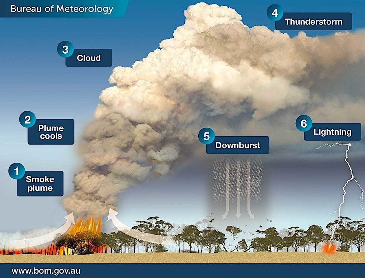
- The Australian bushfires are generating 'pyrocumulonimbus' clouds, according to the Victorian Bureau of Meterology
- These clouds can lead to thunderstorms, lightning and severe winds - that can spread existing fires or start new ones.
The bushfires in Australia are now so big that they are generating their own weather, in the form of giant thunderstorms that start more fires, according to the Bureau of Meteorology in Victoria.
"Pyro-cumulonimbus clouds have developed to altitudes over 16km in East #Gippsland this afternoon. These fire-induced storms can spread fires through lightning, lofting of embers and generation of severe wind outflows," the bureau tweeted on Monday.
Satellite photography shows the intense smoke generating atmospheric clouds:
Intense fires generate smoke, obviously. But their heat can also create a localized updraft powerful enough to create its own changes in the atmosphere above. As the heat and smoke rise, the cloud plume can cool off, generating a large, puffy cloud full of potential rain. The plume can also scatter embers and hot ash over a wider area.
Eventually, water droplets in the cloud condense, generating a downburst of rain — maybe. But the "front" between the calm air outside the fire zone and a pyrocumulonimbus storm cloud is so sharp that it also generates lightning — and that can start new fires.
If powerful enough, a pyrocumulonimbus storm can generate a fire tornado, which happened during the Canberra bushfires in 2003.
Scientists worry that "pyroCbs" are on the rise around the world, driven by warmer temperatures and more intense fires, Yale E360 reported. Their plumes are so strong that they can even shoot smoke into the stratosphere, 6 to 30 miles above the Earth's surface.
Here is a time lapse of a pyrocumulonimbus storm in action, from a different Australian fire:
Don't miss any update on this topic
Create a free account and access your personalized content collection with our latest publications and analyses.
License and Republishing
World Economic Forum articles may be republished in accordance with the Creative Commons Attribution-NonCommercial-NoDerivatives 4.0 International Public License, and in accordance with our Terms of Use.
The views expressed in this article are those of the author alone and not the World Economic Forum.
Stay up to date:
Future of the Environment
Related topics:

Forum Stories newsletter
Bringing you weekly curated insights and analysis on the global issues that matter.
More on Nature and BiodiversitySee all

Felipe Carazo and Lindsey Prowse
March 27, 2026


